Unit 3: Geology |
|
Interactive Science Notebook
Here is the Table of Contents (ToC).
If you are ABSENT, look at the TOC to see if pages have been added. You are responsible for keeping your notebook up to date. Left-hand pages are ones that are student thinking and this must be your own work. Right-hand pages are group or teacher-directed and can be photocopied using the class photocopier.
Table of Contents (ToC) for Geology 2017-18
Task
You have been chosen to find the best location for a new human settlement in the Larkspur-Corte Madera. However, there are many things you need to consider in order to survive in this new world. One consideration is to minimize the risk from earthquakes, landslides, and the rise of sea water.
Big Aha! Question
How does the landscape change over time, and how can my understanding of that help me prepare for the FUTURE?
Focus Questions
Enduring Understanding
Here is the Table of Contents (ToC).
If you are ABSENT, look at the TOC to see if pages have been added. You are responsible for keeping your notebook up to date. Left-hand pages are ones that are student thinking and this must be your own work. Right-hand pages are group or teacher-directed and can be photocopied using the class photocopier.
Table of Contents (ToC) for Geology 2017-18
Task
You have been chosen to find the best location for a new human settlement in the Larkspur-Corte Madera. However, there are many things you need to consider in order to survive in this new world. One consideration is to minimize the risk from earthquakes, landslides, and the rise of sea water.
Big Aha! Question
How does the landscape change over time, and how can my understanding of that help me prepare for the FUTURE?
Focus Questions
- If you were Alfred Wegener, how would you explain your Theory of Continental Drift?
- How does the evidence from seafloor spreading support Alfred Wegener’s Theory of Continental Drift?
- How do the movement of tectonic plates cause geological events, like earthquakes, and share the landforms we see today?
- How does understanding the location of different faults and earthquakes help you plan where to build a human settlement in Marin County?
- How does understanding the activity of different faults and earthquakes help you plan where yo build a human settlement in Marin County?
- How does understanding how earthquakes can cause damage at great distances help you plan where to build a human settlement in Marin County?
- How does the density of basalt and granite in the earth’s crust affect the formation of land?
- What effect does the cooling rate have on crystal formation?
- How do slope and the volume of water affect erosion?
Enduring Understanding
- Mapping the history of natural hazards in a region combined with an understanding of related geologic forces can help forecast the locations and likelihoods of future events.
Key Vocabulary
If you are an English Language Learner, then you are responsible for the words with an asterisk (*). Here are vocabulary cards on Quizlet. MAKE CARDS.
|
Plate tectonics*
Continental Drift Theory* Inner Core Outer Core Mantle Crust Lithosphere Aesthenosphere Density* Mass* Volume* |
Triple beam balance
Scale* Graduated cylinder* Meniscus Earthquake* Fault* Fossil* Seismic waves Epicenter* Focus Moment Magnitude Scale Modified Mercalli Intensity (MMI) Scale |
Transform boundaries*
Divergent boundaries* Convergent boundaries* Seafloor spreading* Liquefaction Landslide* Slump Convection* |
Lessons
7.3.0 Entry Task - Continental Drift
Day 1 (SUB Feb. 10) - Setting up ToC, Unit Title Page & Big Aha!, Feedback on Unit 2, & Month 5: 2 Steps a Month
Day 2 (Feb. 11) - Alfred Wegener: Explore the evidence & CER
Feb. 12/13 - Work on Endangered Species PPT & Video
Feb. 14 - Present Endangered Species PPT
Day 3 (Feb. 24) - Review Alfred Wegener: CER & Endangered Species Action Plan - sit with Ecosystems Partner
Day 4 (Feb. 25) - ... and there is more evidence! Seafloor Spreading
Feb. 26/27 - Garden
7.3.1 Plate Tectonics
Day 5 (Feb. 27/28) -Earthquake Mapping & Tectonic Plates; Review CER Seafloor Spreading
Day 6 (March 2) - Fault Activity (See "Fault Activity" section below)
Day 10 (March 3 - SUB) - Reading: Earthquakes - ABSENT? Come in during advisory or schedule a time at lunch to complete reading.
March 4/5 - Submit Alfred Wegner - Evidence; 2 Steps a Month: Month 5; Redo Reading: Earthquakes; Graphic notes or One pager; Big Aha!
Day 8 (March 5/6) - Did you Feel It!; sign-ups for videos
Day 9 (2020 version) (March 9) - Finish Did you Feel it! CER Graphic Organizer
Day 10 (March 11/12) - Earth's Crust's density: Basalt and granite task
Day 11 (March 13 - SUB) - Earth's Crust CER - do calculations & write CER
7.3.2 The Rock Cycle
Day 12 (March 17) - Earth's Processes: The Crust & Convection
Day 13 (March 18) - Earth's Processes: Modeling the Rock Cycle (Interior & Exterior) & 2 Steps a Month: Month 6
NOT UPDATED BELOW THIS...
Species Recovery Plan Orangutans Project
Skipped these lessons below in 2018-19
Day 11 ( ) Earth's Processes: The Interior - Crystallization (Salol Crystals)
Day 12 ( ) - Finish CER Igneous Rock Cooling & Earth's Processes: Interior
Day 13 ( ) - Earth's interior Processes & Uneven Distribution of Resources: Copper
Day 14 ( ) - Finish Uneven Distribution of Resources & Temporal & Spacial Scales (Day 15)
7.3.3 How Water Shaped the Earth
Day 15 (March 12/13) - Stream Tables & Features of a River HW - work on Big Ahas
Day 16 (March 13/14) - Larkspur Map & Reading Sea, Level Rise (Day 17)- Any last bits Reducing Ocean Plastic Pollution
Day 17 (March 15) - Reading: Sea Level Rise, Erosion, & Weathering & quick Ocean Pollution Check in
PREP: Freezing and Thawing
Skipped 2018-19 Day 17-19
Day 17 ( ) - Reading on Sea Level Rise, Erosion, & Weathering
Day 18 ( ) - Earth's Exterior Processes: Notes & Videos
Day 19 ( ) - Earth Exterior Processes: Modeling
7.3.S Summative Task: Catastrophe!
Day 20 (2nd Period - March 18 & 20; 7th period - March 19 & 20) - Go to Summative Task page - Show Lunch & Raffle kids how to log on
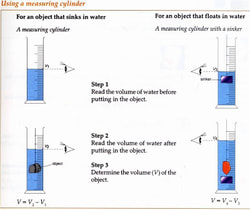
Density of Earth's Crust CER
- Lab: Density of Earth's Crust - When you are done, you will PRINT this out. Turn it in as a separate grade, then you will put it in your notebook.
- How to find the density of irregular shapes
- Background information: Basalt & Granite - NOVA video
- Water Displacement: Eureka - TedEd Video; Optional but cool! The real story of Archimedes' eureka moment - TedEd video)
- How to make tables, superscripts & subscripts - Video - NOTE: Watch the entire video
Fault Activity
Student Resources
Fault Activity (MAKE A COPY) Print it out and paste into your notebook on the appropriate page when done.
Resource 1: How Close to a Fault Do You Live Map
Focus Question: How does understanding the location of different faults and earthquakes help you plan where to build a human settlement in Marin County?
BayQuakeAlliance.org/howclose/ - Shows fault lines in the Bay Area.
Resource 2: Fault Activity Map
Focus Question: How does understanding the activity of different faults and earthquakes help you plan where yo build a human settlement in Marin County?
http://maps.conservation.ca.gov/cgs/fam/ - Make sure when you go on this site, you click the explanation on the right to help you better understand this map.
Did you Feel it!
Focus Question: How does understanding how earthquakes can cause damage at great distances help you plan where to build a human settlement in Marin County?
Did you Feel It! CER (MAKE A COPY) Print out when done.
Bay Area Zip Code Map
Did You Feel It (hard copy available in class too) NOTE: You will need graph paper to plot intensity.
Helpful Resource: Modified Mercalli Intensity Scale (MMI) animation! Click on the different MMI scale numbers to see what people can observe during an earthquake of that magnitude. (NOTE: This is a flash animation and may not work on iPads.)
Further Exploration:
Other resources about earthquake impacts from the Association of Bay Area Governments:
a. Shows shaking hazards from earthquakes.
b. Liquefaction susceptibility is also included. Liquefaction happens when loosely packed soil is full of water and behaves like a liquid when an earthquake happens = buildings sink.
c. Earthquake-induced landslide hazards included.
NOTE: Click on the "Hazards" tab at the top to learn about other hazards such as tsunamis, droughts, wild fires & climate change.
Teacher Resources and things I didn't get to:
Scientists unpack recent 7.0+ magnitude earthquakes & lots of other seismic resources (IRIS.edu/earthquakes)
From Previous Years
Project
Our Dynamic Earth Pop-up Book Project
Dynamic Earth Interactive Science
Continental Drift
Continental Drift - Mr. Sammartano
Seafloor Spreading
Our Layers Song - Mr. Z's video
Plate Tectonics & Plate Boundaries
Plate tectonics video - 7 min. overview; not professionally done but has key elements
Plate tectonics dance video - Mr. Lane's class
Plate Tectonics: Past, Present & Future - click on an animation to show what the Earth looked like or may look like in the future.
Plate Tectonics Interactive: plates and boundaries
The Dynamic Earth
Plate Tectonics - Mr. Andersen
Faults
Joints & Faults video
Earth's Interior
Down to the Center of the Earth National Geographic video - starting at 15:30-20 min San Andreas Fault and plate tectonics discussion - actually better as an end of the year, review of rock cycle - plate tectonics, etc.
Games
Suduction Zone Game - Local rock game from USGS - Play for extra credit and print out your record
Nature Valley Trail View- Interactive trail guide to National Parks, including Grand Canyon, Yellowstone
Glaciers with Chocolate - MIT video
Journey to the Center of the Earth in a cake - MIT video
Study Guides
Rocks on the Move Vocabulary Flashcards
Rocks on the Move Study Guide #1
Rocks on the Move Study Guide #2 & Study Guide #2 KEY
Rocks on the Move Test Study Guide #1 KEY
1. KNOW: Where and how is new crust created? What is this process called?
Ocean: New crust is created where plates move apart. it usually happens along a mid-ocean ridge underneath the ocean. The process is called sea-floor spreading. What happens is that two plates move apart and molten material from the asthenosphere below rises to fill the gap. As the magma reaches the ocean it cools down, forming new crust. This new crust pushes older crust away from the ridge.
Land: Sometimes plates separate on land (two pieces of continental crust moving away from each other). When this happens, a rift valley forms which can result in a large lake or sea.
2. ANSWER: Where and how is old crust destroyed? What is this process called?
As old crust gets pushed away from the mid-ocean ridge, it eventually reaches the edge of another plate. Oceanic crust is more dense than continental crust, so it will get pushed down into the mantle. This happens at a deep ocean trench, and the process is called subduction. Eventually the plate that sinks back into the mantle will melt and become magma.
3. ANSWER: Why does ocean crust sink below continental crust?
Oceanic crust is denser than continental crust, so it will get pushed down into the mantle.
4. ANSWER: What type of boundary is where the North American plate and Pacific plate meet?
Transform boundary
5. KNOW: What are the three types of plate boundaries?
sliding (transform), colliding (convergent), spreading (divergent)
6. ANSWER: How do the plates move at each type of plate boundary?
sliding (transform): slide past each other
spreading (divergent) = moving away from each other
colliding (convergent) = moving towards each other
7. ANSWER: Be able to tell what land features occur at each type of boundary and why they occur there.
spreading (divergent) = mid-ocean ridge under the ocean; on land results in lakes, volcanoes
sliding (transform): results in faults and earthquakes
colliding (convergent) = if two continental crust pieces run into each other, it creates mountains (like the Himalayas; if continental crust and oceanic crust run into each other, the oceanic crust is pushed into the mantle and melts. The magma then rises up and pushes through the continent,making a chain of volcanoes along the edge of the continent.
8. KNOW: What are the focus and epicenter of an earthquake?
The focus is the point inside the Earth where an earthquake begins. The epicenter is the point on the Earth's surface above the focus.
9. KNOW: Why do most earthquakes and volcanoes occur at the plate boundaries?
The plate boundaries are the most active seismic areas. The forces of plate movement causes earthquakes. At plate boundaries, huge pieces of crust collide or spread apart and can result in fractures allowing magma to reach the surface.
10. ANSWER: What are the Richter, Moment Magnitude Scale (MMS) and Mercalli Scale. Compare and contrast the three scales.
The Richter Scale is a scientific scale measuring the magnitude (strength) of an earthquake. Each number up is 10 times greater. This scale is now replaced by the Moment Magnitude Scale (MMS), which is basically the same, but the way they calculate the magnitude of an earthquake is considered more accurate. The Mercalli Intensity Scale is based on observations. You can click on the link to see a simulation of what the different numbers on the scale represent.
